Recording
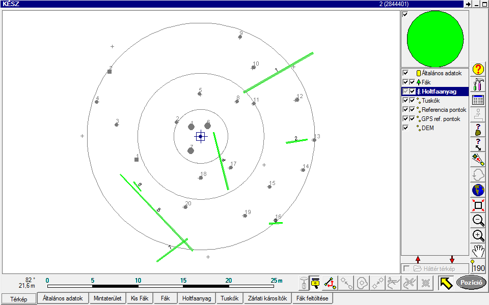
If a sampling point is located in a forest land area, then a fixed circular sampling plot is identified in the field, which is defined by its centre point and a radius of 12.62 m (500 m2).
Recording sampling points
The following parameters are recorded as independent strata at each sampling point:
- General Data
- Sampling plot data
- Sample trees (Trees)
- Small trees
- Lying dead trees (Dead wood)
- Stump
- Pests to be quarantined

Layout by strata of the parameters recorded at sampling points
Entering General Data
Magnetic declination
This identifies the average value of magnetic declination (3.6) typical in Hungary. The value is uploaded into the project before field work.
Circumstances of recording
This field serves to capture whether recording occurred in easy, medium, difficult or extreme terrain.
Measured EOV_Y, X
This contains the true coordinates of the sampling point as measured by GPS. If a point is shifted, the coordinates of the position after shifting need to be entered. If a sampling point is inaccessible or cannot be visited exactly due to fencing or some other reason, the theoretical coordinates need to be entered.
Shift direction
This field serves to capture the direction of shifting a sample point.
GPS reading accuracy (± m)
The GPS measurement error reading in meters.
Point status
All of the sampling points regarded to be field points are uploaded to the field computer during point preparation. However, field review may determine that a field point is not located in forest land area, or in some cases it is not possible to get anywhere near a certain point to determine the rating of that point. The case listed above need to be classified in the Point status field in one of the following categories:
1 Forest land area
2 OWL_Other wooded land
3 Only forest polygon (managed)
4 Shrubbery
5 Unstocked area
6 Agricultural plantation in character (such as orchard)
7 Sampling plot affected by other land use category (water)
8 Ride wider than 6 m
9 Forest belt narrower than 20 m
12 Not larger than 5000 m2
10 Inaccessible
11 Arboricide energy plantation
Record date
The date of recording
Image IDs
The identifier of the photo image taken of the sampling point. A minimum of 2 photographs must be taken during the first cycle, which should provide a general view of the site and may also help answer some questions during processing.
Record lead by (Name of record taker)
The name of the leader of the recording group.
Assistant
Name of the staff assisting in recording.
Comment
This field serves to capture all useful information about the sampling point and the circumstances of recording to get more meaningful data.
Directorate
The name of the Directorate with competence over the location of the sampling point (current county level government office).
Name of settlement
The name of the settlement that the sampling point belongs to.
Sub-compartment identifiers (Compartment, Sub-compartment, Sub-compartment unit)
If the area is included in the National Forest Database, the database identifier should be entered.
Sub-compartment type:
Enter whether the sampling plot is a forest sub-compartment, other sub-compartment or is not subject to forest management
Topography
Enter the topographic categories of the sampling circle by selecting from the list of codes.
Altitude above sea level
A GPS value obtained for the centre point of the sampling plot
Exposure
Enter the typical exposure of the sampling circle indicated by compass points, and if the sampling point is located in a flood plain, its exposure based on the list of codes.
Slope
Enter the angle of slope in degrees after measuring the average inclination of the sampling plot. The measurement is easy to perform using the height meter provided as part of the instrumentation
Degree of water management
See list of codes.
Climate
Enter a value from the list of codes. To identify the climate, take into account both the sampling circle and the larger area (mesoclimate).
Hydrology
Enter a value from the list of codes.
Genetic soil type group
This is to help classify "genetic soil type".
Genetic soil type
Select the precise genetic soil type from the "Genetic soil type group". See list of codes.
Thickness of topsoil
See list of codes.
Physical soil type
See list of codes.
Soil damage
See list of codes.
Use
Describe the most recent method of use during the past 10 years based on judgement if visible signs exist.
Year of use
Estimated year of most recent use.
Uncertainty
The system uploads uncertainties identified during field work preparation so as to help the leader of the recording team determine the status of the point.
Recorded at previous location
If a previous sampling point exists, this is to capture whether the new sampling is performed at the same point or at an alternative point.
Filling in the sampling plot form
Sampling plot status
- Stocked
The sampling plot meets the conditions precedent to recording, it is covered with 7 cm or thicker specimens. (The sampling plot contains at least a single recorded sample tree!)
- Felling site
Enter this value if all of the trees were cleared in the sampling plot, and there are no specimens that are thinner than 7 cm. This is also the value to enter if trees have been cut on the sampling plot only but the forest sub-compartment is still standing.
- Understocked forest land area
An uninterrupted unstocked area of no more than 0.5 hectares without any sample trees or small trees, which is not unstocked due to use. These are normally understocked patches due to site errors in a forest sub-compartment.
- Non-sampling point
Enter this classification if the status of the point is identified as forest land area, and yet the sampling plot cannot be created (e.g. the centre point is located in forest land area, but the sampling plot includes other areas of more than 50 m2, and shifting does not improve the status).
- Obstacles to sampling
There is a significant difference between the possible values "Inaccessible" and "Obstacles to sampling" under "Point status" in "General data" in that the sampling plot can be definitely classified as forest land area in the latter case and the obstacle is only encountered after that decision has been made.
If a sampling plot is out of reach and there is no evidence to substantiate that it is forest land area, enter the value "Inaccessible" in the "Point status" field under "General data".
- Small trees
A sampling plot where the thickness of all of the specimens is less then 7 cm. Use this classification when a sampling plot has been cut but it has natural or man-made regrowth that meets the system of criteria applicable to small trees. Germinating plant with seed-leaves need not be recorded.
- Young stand
Use this classification if there is not even a single recordable sample tree in a concentric circle, but small trees are identified in the wider circle and they are not classified as sample trees due to nothing else but segmentation.
Actual forest association group
This is an auxiliary field that offers a list of 23 types used by the forest authority to select from. It helps classify "actual forest associations".
Actual forest association
This field is used to specify exactly the actual forest association in the selected "Actual forest association group" based on observations at the sampling plot. If the sampling plot has small trees only, the actual forest association cannot be entered.
Potential forest association group
This is to help classify "Potential forest association". Select "No", if you think there is no potential for a forest association at the specific location.
Potential forest association
Enter the potential natural forest association group, regardless of the actual forest association.
Multiple levels
This field serves to enter whether the stand on the complete sampling plot is unstocked, single level or multilevel or potentially a selection forest.
Closure_first.level_%
Enter the percentage of canopy closure for the first or only level, which is maximised at 100%.
Closure_second.level_%
Enter the percentage of canopy closure of any additional levels, which is maximised at 100%.
Shrub cover
This field serves to describe the shrub cover in the sampling plot. Describe the degree of shrub cover and also estimate the type of coverage (homogeneous or in colonies), using the categories of forest management plans.
Ratio of invasive shrubs
The ratio of invasive shrubs in proportion to the total shrub cover in the sampling plot at 5% accuracy.
Herbaceous cover
This field serves to enter the herbaceous cover in the sampling plot relying on the categories also used in the description of shrub cover.
Dead branch cover
This field serves to provide an estimate of the coverage of the sampling plot with dead branches (which are shorter than 1 m or less than 10 cm in diameter and are neither classified as dead wood nor marked in maps) (the degree to which the area is affected by dead branches).
Distribution of dead branches
This serves to provide information about the location of dead wood classified as dead branch coverage.
Area of accumulated dead wood (m2)
An estimate of the area occupied by dead wood accumulated in the sampling plot due to direct human intervention. This serves to identify stacks, strips of stumps, heaps of branches and twigs and any trees fallen to the ground during or immediately after utilisation (which will presumably be removed from the sub-compartment later on). Individual fallen stems should be recorded during the recording of "deadwood".
Accumulated dead wood (m3)
The estimated volume of dead wood accumulated in the sampling plot.
Cause of damage to nature
If major damage to nature is observed, the cause should be identified, if it is not possible to enter such instances as fallen deadwood, or the risk of accidents exists.
Area of damage to nature (m2)
The size of the area affected by damage to nature at 0.1 m2 accuracy.
Damaged nature (m3)
The volume of wood affected by damage to nature at 0.1 m3 accuracy.
Canopy closure of small trees at the sampling plot (3m circle)
This field serves to enter the percentage of canopy closure of small trees with breast height diameter below 7 cm inside a circle with a radius of 3 m. In each case, the value should refer to the circle with a radius of 3 m.
Drilled tree species:
The species of the tree selected outside the sampling circle for increment boring, the species of which is identical to the typical species in the sampling circle.
Drilled tree diameter_(mm)
The diameter of the tree selected for increment boring.
Drilled tree bottom diameter_(mm)
The diameter of the drilled tree at the presumed height of cutting for logging purposes (approx. 10-20 cm above ground, provided buttressness is not disproportionately large at that height).
Bore_length_(mm)
The full length of the bore removed from the drilled sample.
Fencing
Information about whether or not the sampling point is enclosed with fences.
Residential area
If a sampling point is located in a residential area, the fact needs to be recorded.
Park forest
If a sampling point is located in a park forest designated for sports, tourism or recreation, the fact needs to be recorded.
Comment
This field serves to enter comments about recording the sampling plot.
Shrub
This serves to identify the shrub species observed in the full area of the sampling plot.
Recording small trees

Taking tally of small trees in the field
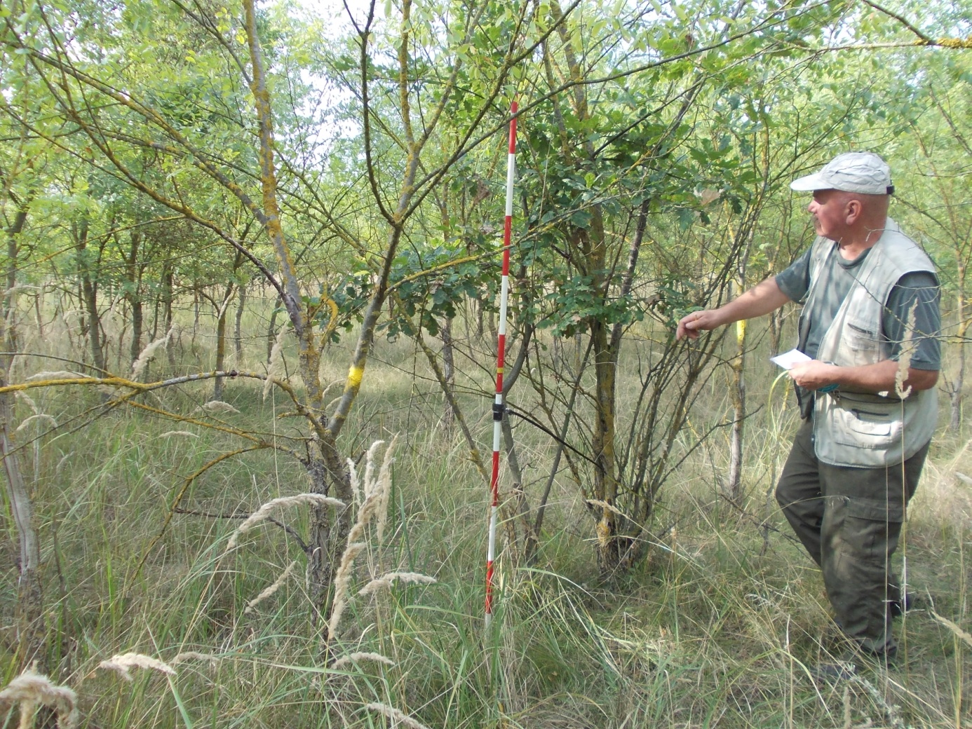
Specimens with a diameter below 7 cm, known as "small trees" should be recorded for the inventory in a circle of 3 m radius around the centre point of the sampling plot.
Records should be taken by height group and by species in each height group with estimated diameter at mm accuracy and whether or not apical buds are damaged due to game browsing for each specimen.
Height groups
Small trees need to be classified into three height groups as described below:
The height of the specimen as measured from soil horizon is
- not greater than 50 cm2
- is between 50.1 cm and 200 cm
- greater than 200 cm
Tree species
This field serves to enter tree species encountered in the selected small area.
Number of trees:
The total number of intact and browsed small trees.
Intact (pieces):
This serves to record the number of specimens not affected by apical bud browsing.
Damaged apical bud (pieces):
This serves to record the number of specimens affected by apical bud browsing.
Avg_Diameter (mm)
The field records in mm the estimated diameter of average small tree specimens of identical tree species and classified in the same height group in the selected sampling plot.
Recording sample trees
Animate and dead (stationary dead) tree specimens should be recorded in the appropriate concentric circle (segment) in line with the expectations identified above, provided they reach the minimum diameter identified for the specific segment, disregarding height group if the specimen reaches 1.3 m. (Dead wood of a height lower than 1.3 m is classified as stump). Specimens with a broken crown or stem should also be recorded as sample trees, provided their height reaches 1.3 m, but the records must show that they are damaged. Sample trees are defines as animate or dead, depending on whether or not they show signs of life.
Assigning sample trees
Sample trees are identified by polar coordinates.
D1,3_(mm)
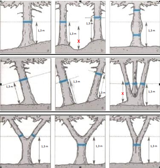
Record the diameter taken at a right angle to the stem at 1.3 m above soil level.
Altimetry
Recording staff needs to take note of the height of animate specimens with a view to the following considerations:
- At least 5 specimens of each main species making up the stand must be measured at each sampling point!
- The height of ancillary tree species needs to be measured if their mixture ratio reaches 10%. If this condition is met, at least 1 measurement needs to be taken; if mixture ratio reaches 20%, at least 3 measurements should be performed.
- To plot a height curve (i.e. to perform altimetry), trees should be selected in a manner to ensure that they meet the following conditions as much as possible:
- The vertical curve to be plotted for the sampling plot should represent almost the whole range of diameters. Do not measure specimens representing the extreme values of diameter distribution, but specimens in the extreme ranges of the dispersion curve must be included in the measurements.
- Taking into account the diameter distribution of specimens in the sampling plot, measurements should be taken of more specimens from diameter groups of higher frequency.
- If possible, select specimens that are easy to see and measure from the set that meets the expectations listed above.

Defining the location of diameter measurements (Source. COST E-43)
Animate canopy bottom
The bottom of the animate canopy should also be measured for animate specimens selected for altimetry.
Decayed canopy bottom
The bottom of the decayed canopy should also be measured for animate specimens selected for altimetry.
Tree species
The tree species of the sample tree
Tree status
As both animate and dead trees are measured simultaneously and a recorded on a single form, it is necessary to distinguish them.
Origin
The origin of the sample tree
Social condition
The social condition of the sample tree in the sampling circle. Sample trees should be rated using Kraft's classification.
The classification of specimens with a broken crown or stem into a height category must always be based on actual condition as observed.
Paint mark
If a sample tree is one of the sample trees with a painted mark left to help identify the centre of the sampling circle, the fact needs to be recorded.
Crown/stem
In the event the crown of a sample tree sustained canopy or stem damage resulting in min ¼ of height loss, the fact shoould be recorded.
Degree of punkiness (for deadwood)
No value should be entered unless the sample tree recorded is dead. The following categories should be used:
- Dead for 1-2 years with intact bark and wood
- Solid wood with occasionally disentangled bark and bast.
- Wood partially punky
- Most of the wood is soft and punky
- Almost completely punky, disintegrated when moved
Age
The age of a sample tree specimen. This value is usually from the National Forestry Database, but may also be copied from the previous Growth Monitoring System data. The data can also be determined by growth ring counting or estimation.
Recording fallen trees (Deadwood)
The full sampling plot should be scanned for mapping stems of dead wood with apical diameter at or above 10 cm, provided the distance between the location of measuring minimum diameter and the thicker end of the stem reaches 1 m (length of deadwood).
Length of decaying fallen deadwood
The length of deadwood is the distance between the butt and a location higher up towards the treetop where cross section still surpasses the average diameter of 10 cm. Only specimen at or above 1 m should be recorded, all other deadwood is noted under dead branches. If a section of a fallen dead tree lies outside the sampling circle, the section outside will be ignored for the purposes of processing the data.
Diameter
Diameter measurements of deadwood should be taken at the smallest location (of minimum 100 mm) – typically at the top – and also at the largest location – which is typically at the butt.
Deciduous/coniferous
The category of the specimen should be indicated.
Degree of punkiness
The degree of punkiness of the specimen should be noted using the categories described for stationary dead wood.
Recording stumps
Stumps inside the sampling plot with a diameter at or above 200 mm should be recorded and marked on a map. (By definition, stumps also include trees with stems broken below 1.3 m of tree height.)
Diameter
The top diameter of the stump identified in mm. If the top diameter fails to reach 200 mm, but it reaches the threshold of selection into the sample at a lower cross section due to significant stump height, the records should show the diameter taken at the lower cross section, the height of which should also be noted.
Stump height (cm)
The height of the stump should be entered at cm accuracy.
Deciduous/coniferous
The category of the specimen should be indicated.
Degree of punkiness
The degree of punkiness of the specimen should be noted using the categories described for stationary dead wood.
Collection of increment cores
Since 2011, an increment core sample is taken of a specimen located outside, but in the direct vicinity of, the sampling plot whose species and approximate size parameters match the main species populating the sampling plot. Drilling should be performed at the height of 1.3 m in the direction of the long leg and taking into account the rules of diameter measurement.
Pests to be quarantined
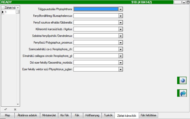
This field serves to indicate the presence in the sampling plot of harmful organisms to be quarantined.

Recording high priority pests that require quarantining