Preparation
Preparatory work is interpreted as the definition of a set of points that either meet the requirements of forest resource assessment or cannot be excluded beyond doubt. As forest inventory jobs are performed independently of other systems, preparatory work covers the whole territory of the country. Sampling locations are studied and classified with reliance on a theoretical grid and Google space imagery. During this process preparation staff must decide whether or not the theoretical grid points (and 500 m2 sampling circles) projected on Google images are terrain points. As each sampling point represents a large area, one should exercise caution to ensure no single sampling point that meets the conditions of sampling based on its terrain parameters should be omitted from sampling in the field. That can only be achieved by dividing potential sampling points into two parts during the preparatory phase. One of these will include all of the sampling locations which the preparatory desk study classifies with absolute certainty as non-sampling locations for forest inventory purposes, while all of the other points are assigned to the other group. Each of the latter, which are known as "field points", must be visited in the field and a decision has to be made whether or not to perform sampling.
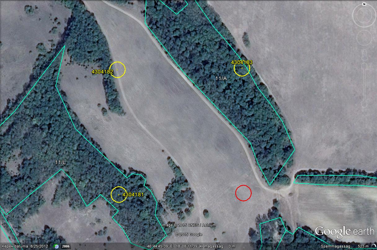
As the first step of the preparatory work one must decide whether or not sampling points are located on wooded area. "On-screen" analysis offers a good view of both grid points and the borderline of 500m2 sampling circles.

Screen shot with sampling point rating
If the image proves that an area is clearly not wooded, the corresponding point is classified as a "non-field point" and the grid point will not be part of sampling in the field.
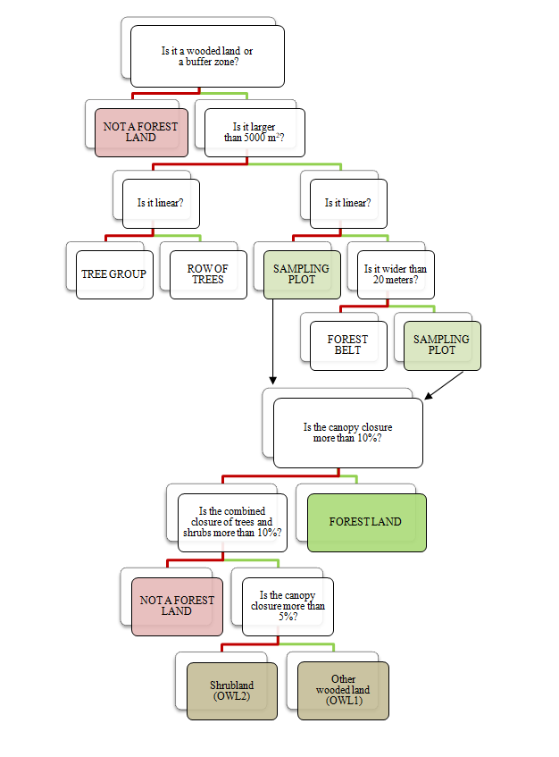
If an area is wooded, additional conditions must be met simultaneously. Phase I is typically classification work in the office while Phase II involves decisions taken in the field, but the evaluation of parameters is not separated so distinctly.
- does the size of the wooded area analysed extend to more than 5,000 m2 or 0.5 hectare without interruption
- if the area falls short of the size required for sampling, then its shape needs to be analysed to decide whether or not it is linear
- if it is not linear then the grid point will be registered as wooded area (cluster of trees) below 5,000 m2.
- if it is linear, then the grid point will be registered as a narrow strip (line of trees).
- if a wooded area extends to more than 0.5 hectare without interruption, its shape needs to be analysed.
- if it is linear, but its width is below 20 m, the grid point will be registered as less than 20 m wide wooded land (forest belt).
- if it is linear, and its maximum width measured across the grid point reaches 20 meters then the grid point will be registered as a field point.
- if it is not linear, but is arranged in a block, it will also be a field point.
- if a grid point is identified as a field point based on the considerations listed above, one needs to judge canopy closure.
- if canopy closure of the trees is over 10%, the point is forest land area.
- if canopy closure of the trees is 5-10% and the combined closure of trees and shrubs reaches 10%, then the point is other wooded land – – (OWL1).
- if canopy closure of the trees is below 5% and the combined closure of trees and shrubs reaches 10%, then the point is shrub covered – (OWL2).
- if the area falls short of the size required for sampling, then its shape needs to be analysed to decide whether or not it is linear
Please note that the international definition treats OWL as a single category, the differentiation is a Hungarian speciality.
- if a grid point meets the conditions listed above, but the sampling circle overlaps with other land use (such as turf, plough field, road, water, etc.), the size of the overlap may not reach 10% or 50 m2. The grid points located at the borderline of wooded areas are in a buffer zone, hence their classification is quite uncertain.
If a decision cannot be made beyond doubt by desk study, a field survey is mandatory. That is the main reason why the number of points identified at the onset of field work is eventually reduced. This method also minimises the threat of omissions.
In the figure, the SE point is located in an unstocked area, points SW and NE are clearly inside the stock, whilst the NW point is located in the buffer zone. The points highlighted in yellow will be checked in the field and may be accepted depending on the outcome of the evaluation. Points that are clearly non-field points based on space imaging are marked red.
Classification by desk study will mark both field points and every point located on a stocked area. These are registered by shape and size and will not be visited in the field. Points that will be classified in one of these categories during field work due to some uncertainty will also end up in this set.
Classifying sampling points
When points are visited in the field, grid points need to be classified in one of the following ("Point status") categories. Actual sampling will only occur at points registered as "Forest land area".
| 1. Forest land area |
|---|
| 2. OWL_Other wooded land |
| 3. Shrubbery |
| 4. Only forest polygon (managed) |
| 5. Unstocked area |
| 6. Agricultural plantation in character (such asorchard) |
| 7. Sampling plot affected by other land use category(water) |
| 8. Ride wider than 6 m |
| 9. Forest belt narrower than 20 m |
| 10. Inaccessible |
| 11. Arboricide energy plantation |
| 12. Not larger than 5000 m2 |
